Massive expansion in Protestant-dominated east Londonderry will push city further into countryside


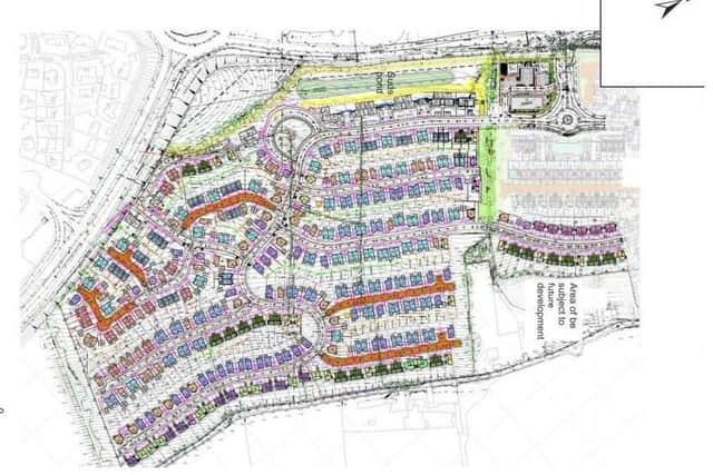
According to the map on the government’s Planning Portal website, the blueprints involve a total of 445 new homes, next to the Crescent Link ringroad.
The homes would be a mix of 138 detached houses, 212 semi-detached ones, 34 townhouses, and 61 apartments.
Advertisement
Hide AdAdvertisement
Hide AdThere would also be public open space including a children’s’ playground, a neighbourhood community centre, a creche, gym, and shops.
All in all, it would cover almost 21 hectares (just over 50 acres).
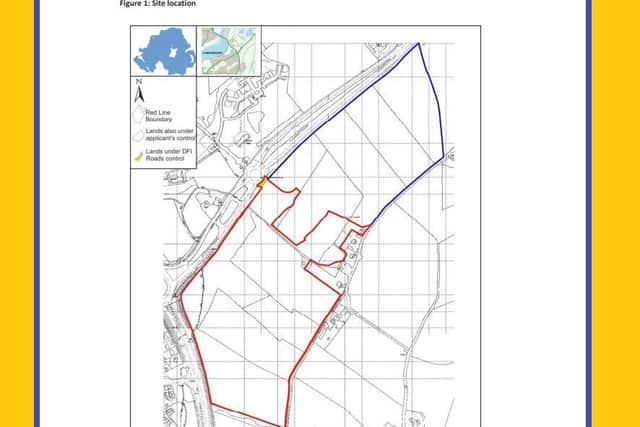
The maps also show that the developer controls a similar-sized chunk of land to the north-east of the site, leaving open the possibility of a further expansion of the housing estate at some point in the future.
The applicant is listed as South Bank Square Limited, based in Maghera.
Advertisement
Hide AdAdvertisement
Hide AdThe application was actually put in during mid-August, and has only come to light after the News Letter performed a trawl of recent planning applications.
Derry City and Strabane District Council is the authority which will decide whether or not to give the project the thumbs up – although there is no date yet set for that to happen.
It falls under the Foyle constituency which is heavily-dominated by nationalists/republicans (with two SDLP MLAs, two SF, and one DUP) – although the eastern banks of the city have a substantial unionist population.
The demographics of the new neighbourhood will doubtless be of interest to politicians.
Advertisement
Hide AdAdvertisement
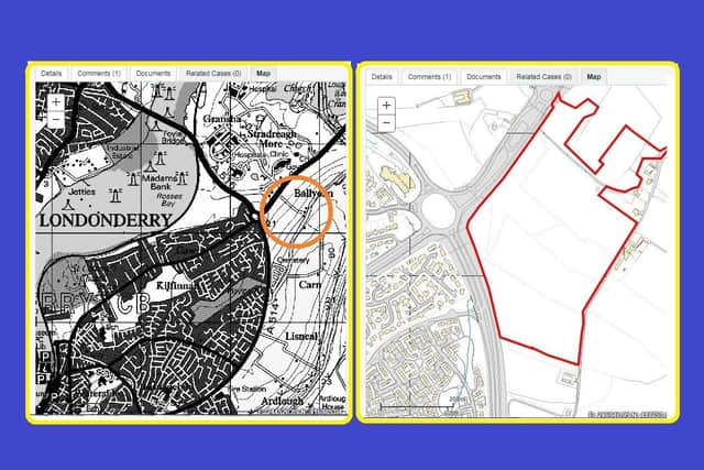
Hide AdThe attached image shows in blue the spread of Protestants in the city (with darker blue representing higher numbers), and the new development area roughly marked out in red.
A report into the development from Derry City and Strabane District Council said that, given it is so close to the main road network, “there will be significant adverse impact on the health and quality of life of residents unless noise levels can be reduced”.
It adds that the applicant knows “noise mitigation measures shall have to be incorporated into the design”, including noise barriers at the edge of the site and upgraded glazing for some of the homes.
Some residents had also submitted a letter, voicing concern about the proximity of the development to a cottege off Rossdowney Road, which they say dates basck to the 1830s and is “one of the oldest houses in Derry” – but this is the only objection listed so far on the Planning Portal website.
Advertisement
Hide AdAdvertisement
Hide AdThe developer has said that, when it comes to homes without cars, buses will be routed to the development, and there will be “excellent accessibility” via “high-quality pedestrian and cycle routes in the local area”.
READ MORE STORIES FROM THIS REPORTER:
CLICK HERE: Publicly funded NI groups spring to defence of vitriolic anti-police transgender activist
Advertisement
Hide AdAdvertisement
Hide AdCLICK HERE: Same-sex marriage: Presbyterians say law to defend Christians’ human rights may be needed
CLICK HERE: Secret documents show top Protestant churchman believed Rev Ian Paisley was a ‘fascist’ provocateur
CLICK HERE: John Hume: IRA were ‘medieval savages weeping crocodile tears’ as they bombed tens of thousands out of work
Advertisement
Hide AdAdvertisement
Hide Ad