
Northern Ireland weather: Met Office snow and ice warning issued as wintry showers expected
Watch the Met Office weekend forecast, as a snow and ice warning is issued for Northern Ireland.
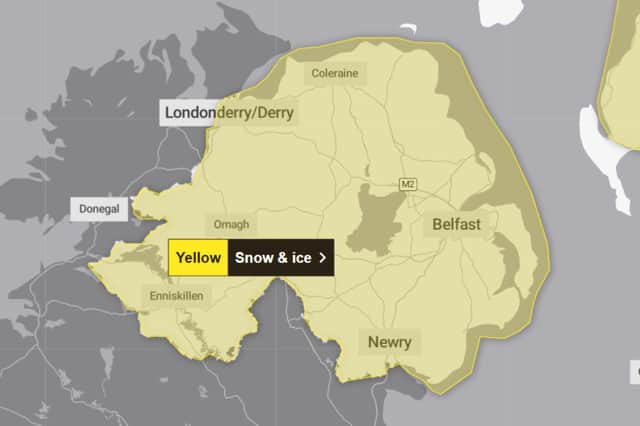
A Met Office warning for snow and ice has been issued for Northern Ireland.
The yellow snow and ice warning will be in place from 17:00 today (Friday January 9) to 11:00 tomorrow (Saturday January 10).
The warning reads: “Icy patches and some hill snow are expected Friday night and on Saturday morning.

“Some roads and railways affected with longer journey times by road, bus and train services. Some injuries from slips and falls on icy surfaces. Icy patches on some untreated roads, pavements and cycle paths.
“Clear spells on Friday evening and overnight will allow temperatures to quickly fall below freezing, leading to the development of icy stretches, especially on untreated surfaces. A scattering of wintry showers are also expected, these falling as snow over hills above 200 m, where further small accumulations of 1 to 3 cm are possible in a few places.”
Met Office Northern Ireland weather forecast
Today (January 9)
The morning will begin cold but mostly dry with a few wintry showers in the west. Wintry showers will spread to the northern and eastern coasts from the morning but inland areas will stay mostly dry. Maximum temperature 4 °C.
Tonight (January 9)
The evening will be dry and frosty with clear spells. Thickening cloud will spread east from the late evening with a band of showery, wintry rain following east towards morning. Minimum temperature -4 °C.
Saturday (January 10)
The morning will be cloudy with showery and wintry rain. This rain will clear east to leave the afternoon dry with bright spells. Maximum temperature 4 °C.
Outlook for Sunday (January 11) to Tuesday (January 13)
Very cold, a band of snow followed by rain, pushes northeast Sunday morning. Becoming milder with dry spells interspersed with showers Sunday afternoon into Tuesday.